
For most of 2026 I argued about acres. Wrong unit. I had the right numbers sitting open in another window the entire time, and I kept reaching for the ones that were easier to say out loud.
The land case against AI infrastructure was simple to make and simple to lose. Data centers were eating farmland, food and water were on the other side of the ledger, and then somebody would produce the acreage and the whole argument would fold. Because the acreage is small.
It is genuinely small. It was never what was being bought.
Why the land was worth selling
Start with the strongest version of the case that beat me.
Andy Masley made it about as bluntly as it can be made: the land use objection, he argued in 2026, is fake. His arithmetic holds. Count every acre inside the fence, parking and setbacks and substation included, and American data centers were on course for roughly 1,400 square miles by 2028, somewhere between 600,000 and a million acres. The buildings themselves came to about 25 square miles. Against 876 million acres of US farmland, that is three tenths of one percent of prime farmland, and for the structures alone five thousandths of a percent. Corn grown for ethanol took around 30 million acres. Land sitting idle in the Conservation Reserve Program came to 40,000 square miles.1
Then the mechanism, which is the part that actually moved county commissions, and it is not a cost curve. It is a tax base. Loudoun County, Virginia publishes the number without embarrassment: data centers occupy about four percent of the county's commercial parcels and yield 38 percent of general fund revenue, more than 100 million dollars of new money a year, which has let the county cut its residential property tax rate every year for a decade to the lowest in northern Virginia.2
That concedes a great deal and I want to be plain about it. Per acre, a data center is close to the most productive thing a rural county can permit. The schools get built. The rate goes down. A farmer holding ground that no child of his wants gets an offer no crop will ever match. Anyone who calls that trade obviously stupid has not read a county budget.
What the volume numbers missed
Here are the figures I should have been working from.
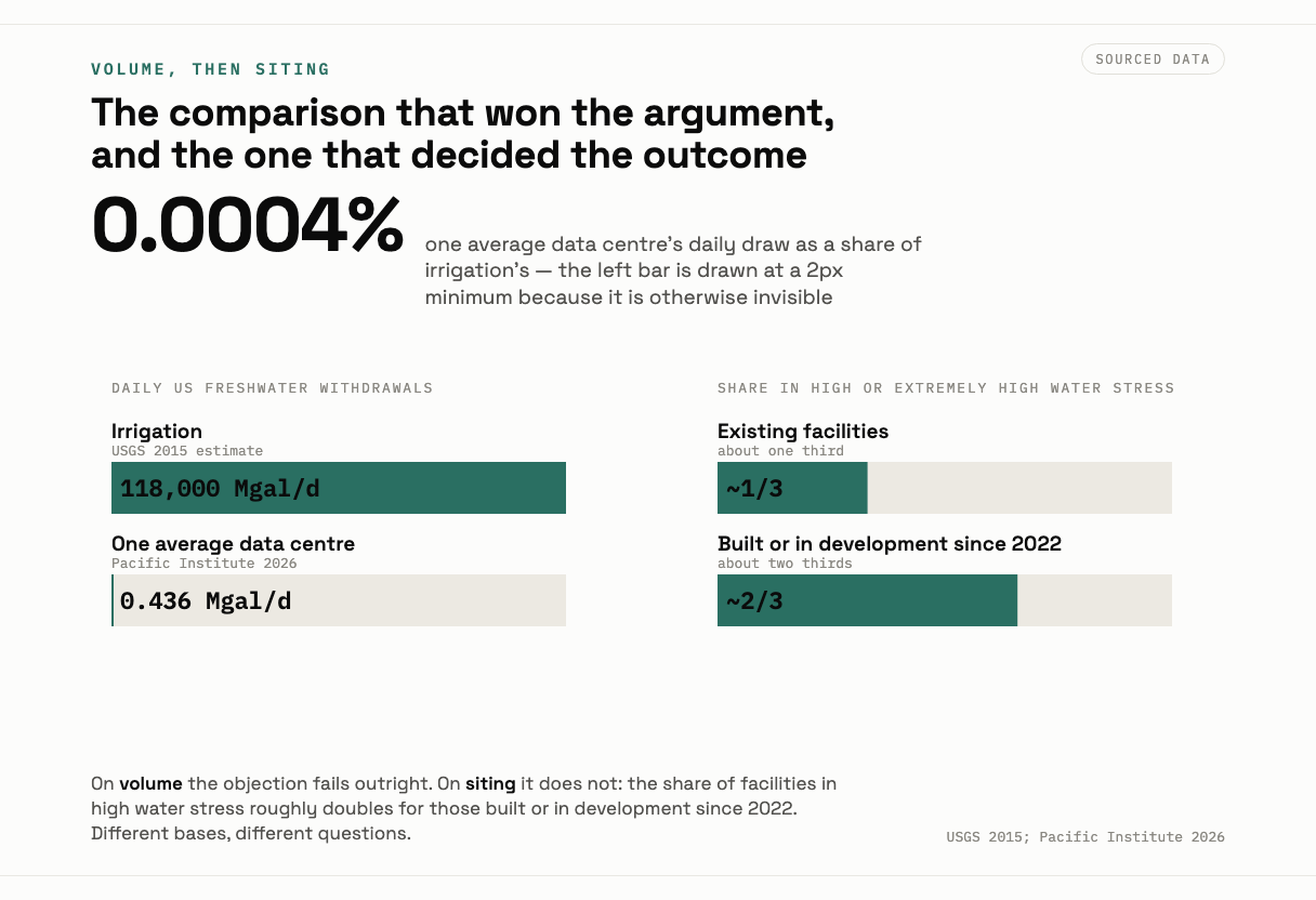
The Pacific Institute went through 65 reporting facilities and published the distribution in September 2026. Median withdrawal of 121,000 gallons a day, average 436,000, with the range running from 270 gallons to 3.9 million. Annually, a median of 44.3 million gallons and an average of 159 million. A typical facility consumes 74 percent of what it withdraws, meaning the water leaves the basin as vapor rather than returning downstream, against about 12 percent for US public water supplies generally. AI facilities ran a water usage effectiveness near 1.8 liters per kilowatt hour, roughly five times the 0.36 of a conventional site. Of 11 billion gallons withdrawn across the facilities evaluated, 76 percent came from potable supply.3
Now set that against agriculture, honestly, because this is where I lost the argument and deserved to. Irrigation in the United States withdrew about 118,000 million gallons a day, roughly 42 percent of all freshwater withdrawals, across some 63.5 million irrigated acres.4 One average facility at 436,000 gallons a day against 118 billion gallons a day is not a competitor. It is a rounding error.
So when the industry said its water use was trivial beside farming, it was telling the truth. I checked that more than once, hoping it was wrong.
The trouble is that a rounding error only stays an error if there is slack. In a basin already allocated to the last drop, a new withdrawal does not take a share of the surplus, because there is no surplus to take a share of. It takes its place in a queue. And a queue is not sorted by volume.
The queue that decided it
Which is where the siting pattern stops looking like coincidence.
Eighty seven percent of existing American data centers sat in urban areas. More than two thirds of the planned ones were aimed at rural communities. Nearly a third of existing facilities were already in places of high or extremely high water stress, and about two thirds of everything built or in development since 2022 went into high stress areas.3 That is not drift. That is selection.
The footprints grew to match. The average new site reached about 224 acres in 2024, up 144 percent in two years, with the largest campuses past 1,000 acres.5 In Mason County, Kentucky a single proposal put roughly 2,100 acres of productive farmland in play, with 10,000 more available if a rezoning passed. Ida Huddleston turned down 26 million dollars for family ground there and gave the clearest summary of the decade: you cannot get food out of a data center.6 In Utah a proposed campus called Stratos was sized at 40,000 acres and about nine gigawatts.6
Then the detail that did the actual work, and it is procedural rather than hydrological. In Oklahoma, data centers avoided water permitting altogether by buying their supply from municipal utilities.7 Google's facility at Pryor ran at about 1.1 billion gallons a year, with roughly 275 million gallons discharged back to rivers.7
Read the permitting part again. A permit application is the moment a state looks at a basin and asks whether there is anything left in it. A purchase order from a city utility asks nothing. It is a commercial transaction between a willing seller with existing rights and a buyer with a balance sheet, and it is complete before the hydrology is consulted.
Irrigation, meanwhile, runs on exactly the supply that gets curtailed first: junior rights, weather indexed allocations, groundwater under declining table. Municipal potable supply is the last category any state in the country will shut off, because no board of any kind wants to explain why a town's taps went dry while a field got watered.
The claim that came with the acre
Four drawers, four filing systems, and nobody had them on one table. A county budget FAQ in Virginia. A USGS withdrawal table whose headline number is twenty years old and still correct in shape. A municipal water purchase agreement in Oklahoma that no hydrologist reviewed. And a datacenter cooling design note from a software company, published in 2024, promising to need almost no water at all.
The acre was never the asset. The asset was a municipal connection a drought cannot touch, and it sold at the price of farmland.
That is the trade that got made, several thousand times, while the argument was about land. The triviality of the volume was not a defense against the siting. It was the reason the siting went through, because an application that consumes a rounding error is easy to approve and arrives in front of a board that counts acres and jobs and assessed value. None of those three instruments measure priority. Volume is what you lose in a shortage. Seniority decides who loses it.
And the engineering answer is real, which I want on the record because it is the strongest thing anyone defending this build can point at. Microsoft's closed loop design, adopted for all new datacenter designs from August 2024, avoids more than 125 million liters a year per facility, with pilots at Phoenix and Mt Pleasant due operational in late 2027. The company says the trade is a higher power usage effectiveness, which it calls nominal.8 So the industry's water problem has a published fix with numbers attached. Two things about it. It arrives after the siting decisions, which are the ones that are hard to reverse. And it pays in electricity, which in a farming basin is the other input the irrigator is buying.
Who won is not complicated: counties that got a tax base and a falling rate, and firms that got a connection with a good seniority date on it. Who paid is the irrigator holding a junior right in a basin where the senior claims have now been issued, and whoever shows up next in that basin wanting water for anything at all, including growing food.
The durable lesson, and I would like it nailed above every zoning counter in the country: a rounding error in volume is still a senior claim in priority. Count the thing that gets rationed, not the thing that gets reported.
Author's Note. This piece is written from 2036 and looks back at 2015 to 2027. The correspondent's first person marks the difference between what was knowable in 2026 and what is obvious from 2036; it records changes of mind, not events. The land area arithmetic, the Loudoun County revenue figures, the Pacific Institute water distribution, the USGS irrigation withdrawals, the siting and footprint figures, the Mason County and Utah proposals, the Oklahoma municipal purchase route, the Pryor withdrawal figure and the Microsoft closed loop design are all real and sourced below. Three boundaries. The USGS irrigation figures are 2015 estimates, the most recent full national accounting available, and are used for scale rather than as a 2026 measurement. Figure 2 is a chart rather than an illustration, and it deliberately places a national sector total beside a single facility average, which are not the same kind of quantity; the comparison is the point and the mismatch is labeled on the chart. And the water rights seniority mechanism described in the last two sections is an inference from the permitting and curtailment practices cited, not a finding from a published study of data center water priority; no claim is made that any named company or county acted unlawfully.